Dataset Open Access
Data publication: Elemental data from transpired fluid from Norway spruce needles of the Horizon 2020 project NEXT
 Pospiech, Solveig;
Middleton, Maarit
Pospiech, Solveig;
Middleton, Maarit
1. Overview
This repository contains the **final, cleaned chemistry data** that were produced from the 2019 Raja field campaign of the Horizon 2020 Project NEXT.
The data combine:
- Norway spruce needle transpired fluids concentrations for a set of selected elements.
- Corresponding soil‑till depth, point location, lithology and basic tree information.
- Element‑specific relative‑standard‑deviation (RSD) uncertainties that were calculated from laboratory‑derived uncertainty parameters.
All files are provided in **CSV** format (UTF‑8, `,` separator) and/or the R programming language binary format RData.
2. Column description
**Field Descriptions for Repository Metadata**
#### **Point Identification & Metadata**
1. **PointID** – Unique identifier for each sampling point in the dataset (e.g., `NEXT-2019-193`).
2. **till_depth** – Depth of the till layer (in meters) at the sampling location.
3. **ID_num** – Numeric identifier for the point (e.g., `193`).
4. **grainsize_2mm_pct** – Percentage of grain size >2mm in the soil sample (proxy for rock fragments or coarse material).
5. **OM_thickness** – Thickness of organic matter (cm) in the soil profile.
6. **Soilwetness_by_photo** – Soil wetness category inferred from field photos (e.g., `mesic` = moist, `sub-xeric` = moderately dry).
7. **Soilwetness_cat** – Numeric ranking of soil wetness (likely 1–7, with `1` = driest, `7` = wettest).
8. **notes_by_photos** – Qualitative observations from site photos (e.g., "paludified areas nearby," "boulders present").
#### **Geophysical & Electrical Properties**
9. **conductivity_ph-acid** – Electrical conductivity (EC) measured after acidification (mS/m).
10. **conductivity_ph-initial** – Initial EC of the soil sample (mS/m).
11. **conductivity_pit** – EC measured in the field pit (mS/m).
12. **conductivity** – Conductivity averaged or processed for analysis (units vary).
13. **dielectric permittivity_pit** – Dielectric constant measured in the pit (proxy for soil moisture).
14. **dielectric permittivity** – Processed or averaged dielectric permittivity value.
15. **pH_initial** – Initial pH of the soil sample.
16. **pH_with acid** – pH after acidification (indicates buffer capacity).
17. **pore water conductivity** – EC of extracted pore water (mS/m).
#### **Geospatial & Environmental Context**
18. **VTEM, TMI, APR** – Geophysical survey metrics (VTEM = Vertical Electromagnetic, TMI = Total Magnetic Intensity, APR = Airborne Radiometrics).
19. **Soilwetness** – Categorical soil wetness classification (e.g., `mesic`, `sub-xeric`).
20. **Soiltype** – Predominant soil type (e.g., `mineral soil`, `peat`).
21. **Naturetype** – Ecological classification (e.g., `Boreaaliset luonnonmetsät` = "Boreal natural forests").
22. **TMI_class** – Categorization of Total Magnetic Intensity (e.g., `low`, `middle`, `high`).
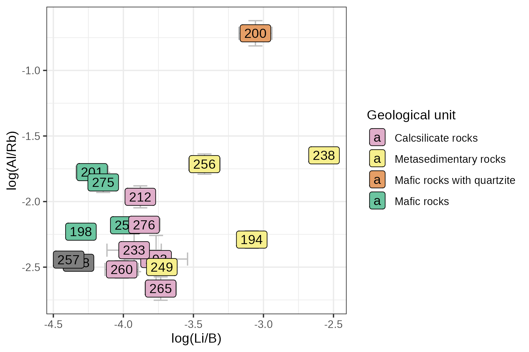
23. **Lithology** – Original rock type classification (e.g., `Calcsilicate rocks`, `Mafic rocks`).
24. **Lithology_updated** – Updated lithological classification (refining earlier interpretations).
25. **Lithology_updated_Sol** – Lithology-specific to soil horizons (e.g., `Mafic rocks + quartzite`).
26. **Mineralization** – Qualitative assessment of mineralized zones (e.g., `barren`, `potential`, `min`).
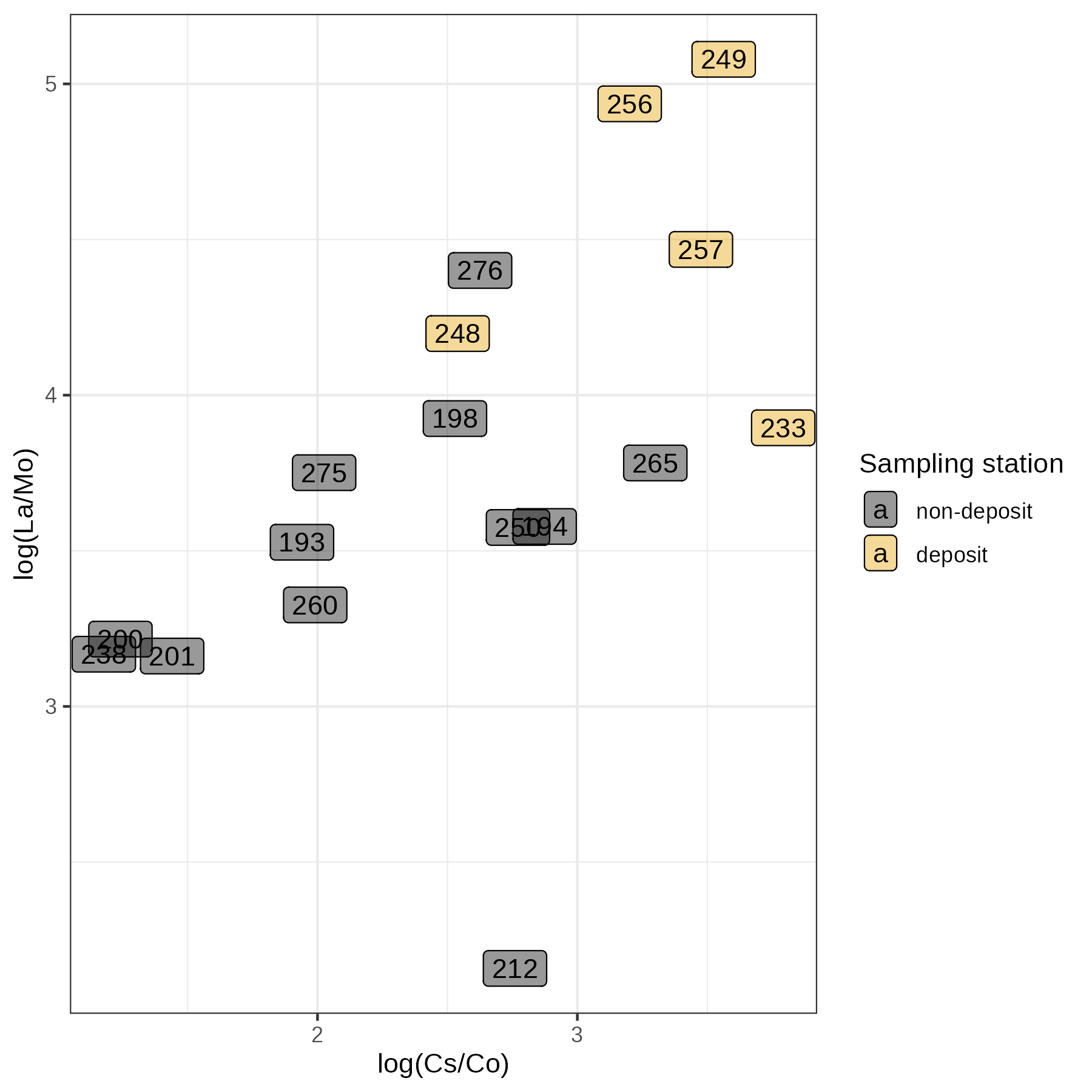
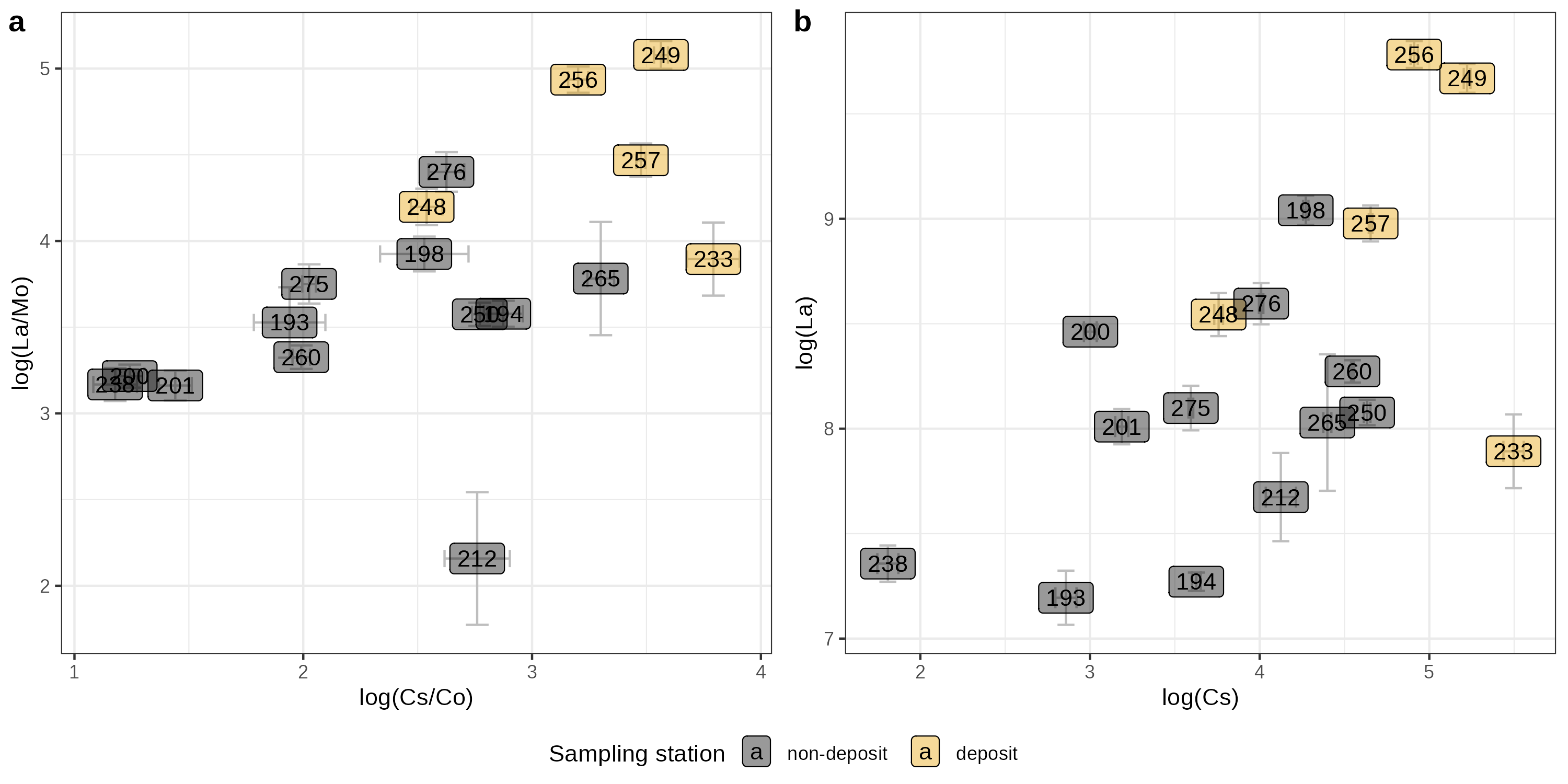
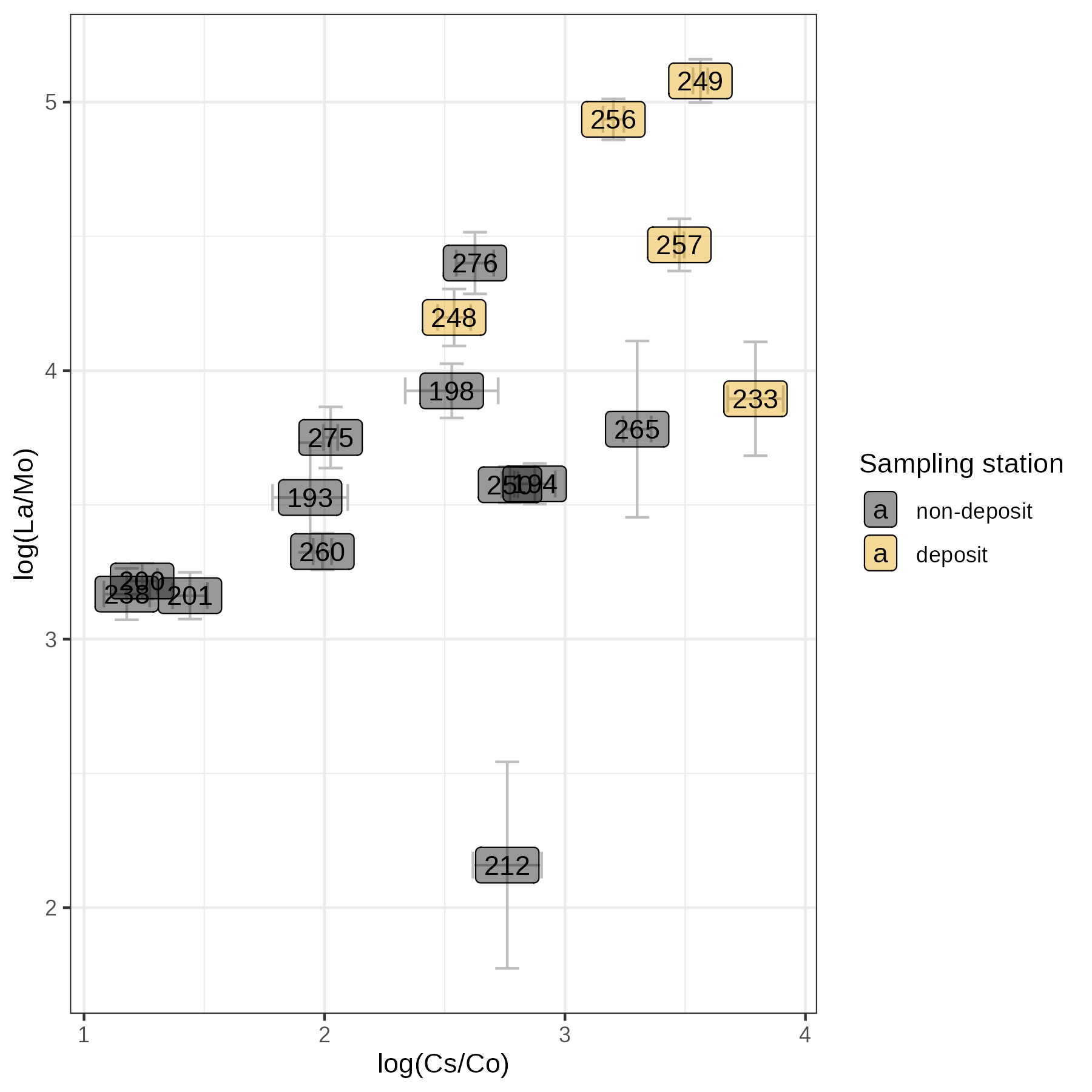
27. **Deposit** – Type of geological deposit (e.g., `Till`, `hardpan layer`).
28. **TMI_cat, VTEM_cat, APPRES_cat** – Categorized geophysical survey results (e.g., `high` intensity).
29. **vegetation_class_EFTAS** – Vegetation classification (e.g., `mesic heath forest`).
30. **i.ID_num** – Redundant numeric ID (same as `ID_num`).
31. **x, y** – Cartesian coordinates for the sampling point.
32. **Fotos** – Reference to associated field photos (e.g., `104-0905`).
#### **Site & Sampling Details**
33. **GeneralSiteDescription** – Textual description of terrain (e.g., "flat, paludified area starts 1m below").
34. **ForestType** – Dominant forest type (e.g., `VMT` = "Välimetsä" [forest type code]).
35. **Soil_paludification** – Degree of peatland/wetland influence on soil (e.g., `not paludified`).
36. **Soil_nutrient_status** – Nutrient availability assessment (e.g., `normal`).
37. **Observations2019** – Anomalies or notes from 2019 fieldwork (e.g., "eggs of gnomes in upper podsol layer").
38. **SedimentType** – Type of sediment observed (e.g., `Till`, `Sand`).
39. **SedimentGenesis** – Origin of sediment (e.g., `glacial`, `alluvial`).
40. **Pointtype** – Classification of sampling point (e.g., `replicate`).
41. **TMI_intensity, VTEM_intensity, APPRES_intensity** – Quantitative geophysical survey intensities.
42. **GPS-Easting, GPS-Northing** – Precise GPS coordinates for the point.
43. **SampleID** – Unique identifier for lab samples (e.g., `TF-NEXT-2019-193-NrS-tf-0A`).
44. **Date_full** – Timestamp of sample collection/analysis.
#### **Geochemical Data**
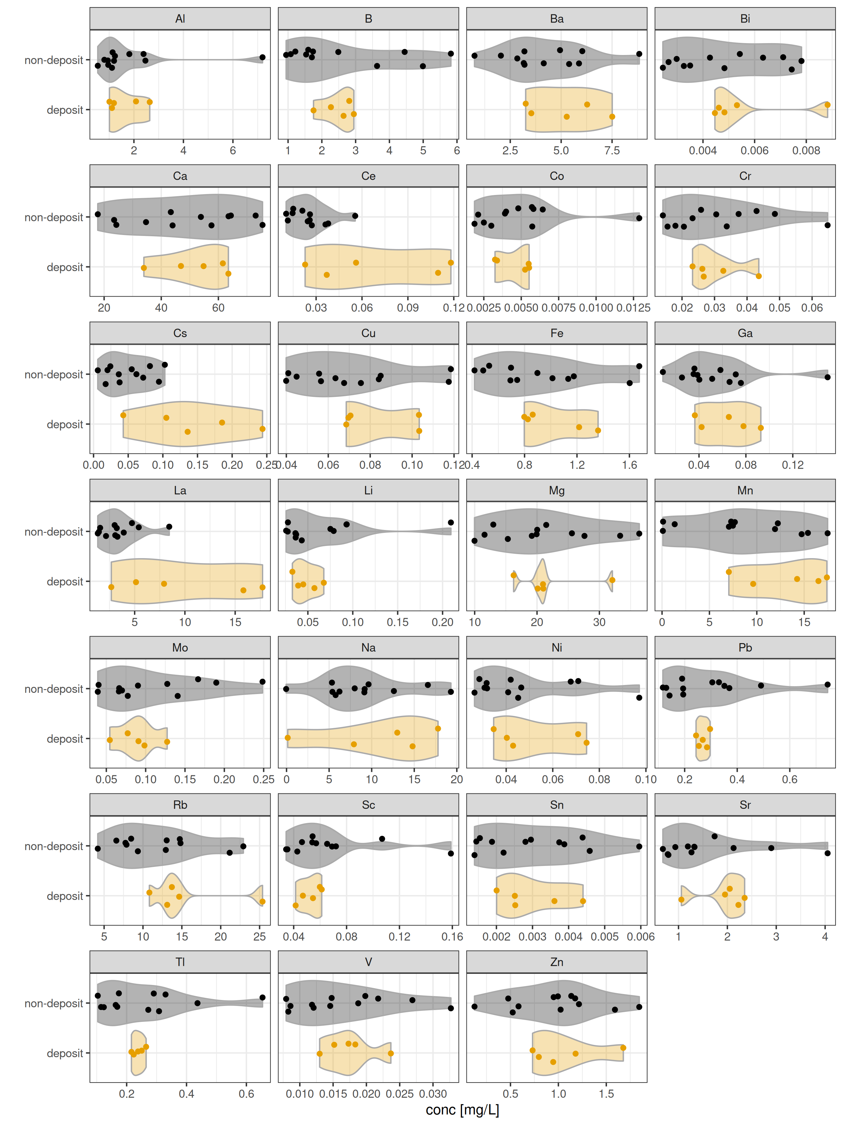
45. **Al, B, Ba, Bi, ... Zn** – Concentrations of elements (likely in **ppm/mg/g**) measured via lab analysis (e.g., ICP-MS).
*Note: These columns represent a full suite of geochemical elements (e.g., Aluminum, Barium, Lead, Zinc) critical for mineral exploration, environmental studies, or soil health assessments.*
---
### **Key Notes for Repository Users**
- **Units**: Conductivity (mS/m), pH (unitless), dielectric permittivity (dimensionless), GPS coordinates (meters, local system).
- **Categorical Fields**: Wetness, lithology, and mineralization use standardized codes (e.g., `mesic` vs. `xeric`).
- **Geophysical Data**: VTEM/TMI/APR are airborne survey metrics linked to subsurface mineralization.
- **Geochemical Data**: Elemental concentrations are essential for understanding soil fertility, contamination, or ore potential.
---
### **Suggested Use Cases**
- **Mineral Exploration**: Cross-reference `Mineralization` + `TMI_cat` with elemental data (e.g., high `Fe`, `Cr` for mafic rocks).
- **Soil Science**: Analyze `Soilwetness` vs. `dielectric permittivity` to model moisture regimes.
- **Ecological Studies**: Correlate `vegetation_class_EFTAS` with `Soil_nutrient_status`.
| Name | Size | |
|---|---|---|
|
Fig3_errorbars.png
md5:99378909db92bfb6b332f8d3ac353b11 |
118.7 kB | Download |
|
Fig4.png
md5:e6c4f35f993afe2ac7f6ab835445c160 |
98.8 kB | Download |
|
Fig4_both.png
md5:998b04356de5178b46bae02c46675b59 |
200.1 kB | Download |
|
Fig4_errorbars.png
md5:ca2075c60b189f38fcab18c7878558ab |
108.7 kB | Download |
|
Fig4_ext.png
md5:a9a3d878d37d922fb6719af5e10e9c93 |
190.8 kB | Download |
|
Fig4_ext_errorbars.png
md5:44a7e60527396359aa512ddba7ea6890 |
107.5 kB | Download |
|
Fig4_full.png
md5:49b25ff35dc4ff663175ff85deaad623 |
319.5 kB | Download |
|
FigAppendix_errorbars.png
md5:d8934d91c13634f312f06221102a1ddc |
102.2 kB | Download |
|
TF_conc_all.png
md5:99e3c33b5664e5cc93bd5a13647ee78a |
710.7 kB | Download |
|
TF_for_publication_versionpublished.R
md5:178b651ef6da3af0ace3846e1a37deae |
7.3 kB | Download |
|
Transpired_fluids_compiled.csv
md5:f0f3967b1b680228823c1933c15a98cd |
20.7 kB | Download |
|
Transpired_fluids_compiled.RData
md5:81fab8746f8b56e58e753a5884a7fdde |
8.8 kB | Download |
|
Transpired_fluids_uncertainties.csv
md5:7dfcae81315543f5b456e04af45e835d |
9.7 kB | Download |
|
transpiredfluids.bib
md5:9a5c3315261190010a039da98b3b4c02 |
24.9 kB | Download |
|
TranspiredFluids_rawdata_counts_RSD.RData
md5:e1e42ea1a0ab72e7adca990711b8c14b |
9.6 kB | Download |
| All versions | This version | |
|---|---|---|
| Views | 40 | 40 |
| Downloads | 17 | 17 |
| Data volume | 1.8 MB | 1.8 MB |
| Unique views | 36 | 36 |
| Unique downloads | 17 | 17 |
- Publication date:
- January 7, 2026
- DOI:
-

- Keyword(s):
- Norway spruce mineral exploration Finland transpired fluid Gold ore geology
- Related identifiers:
- Identical to:
https://www.hzdr.de/publications/Publ-42687 - Referenced by:
https://www.hzdr.de/publications/Publ-41163 - Supplementary material:
https://www.hzdr.de/publications/Publ-41163 - Communities:
- License (for files):
- Creative Commons Attribution 4.0 International